

Exploration Support
Exploration programs often begin in areas where reliable terrain information is limited or outdated. Without clear topographic context, evaluating targets and interpreting surface conditions across large areas can be challenging. RPM’s aerial LiDAR provides a high-confidence terrain baseline across large, remote exploration blocks, delivering detailed DEMs, contours, and terrain derivatives that give exploration teams a clearer view of the landscape. These datasets support the interpretation of surficial and Quaternary geology, help identify potential outcrop locations and structural patterns, and provide valuable topographic context for integrating and interpreting geophysical data. By improving understanding of terrain and surface expression, LiDAR can help exploration professionals identify areas of interest, make more informed predictions about subsurface geology, and focus efforts on the most promising and cost-effective targets, while also supporting access planning in challenging terrain.
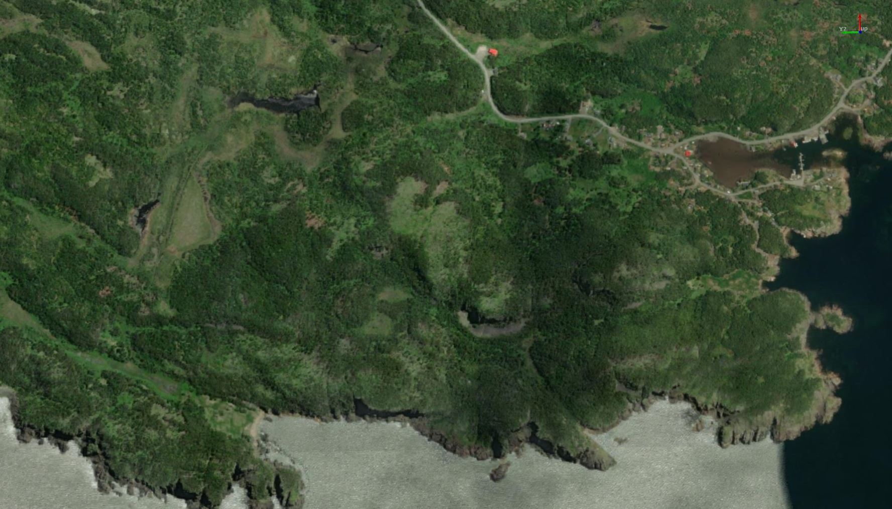
Aerial LiDAR
Hover to see aerial LiDAR data on a map.
Mining & Project Development Support
As projects move toward development and production, detailed terrain data becomes essential for infrastructure planning and operational logistics. RPM’s LiDAR datasets support mine planning and site development activities including road and pad siting, slope and drainage evaluation, infrastructure layout, and logistics planning across complex terrain. High-resolution DEMs provide the topographic foundation needed for engineering studies, site design, and operational planning, helping teams make confident decisions based on accurate terrain data.
Service Capability
RPM brings years of experience working in Atlantic Canada and deep familiarity with local terrain and operating conditions. Depending on the area to be covered and site conditions, RPM can deploy helicopter or drone LiDAR and recommend the most economical, efficient approach to get the data you need on schedule. Deliverables integrate cleanly into GIS and engineering workflows.
RPM Provides:
- High-resolution digital elevation models (DEMs), contours, and terrain derivatives to support exploration and mining analysis
- Large-area LiDAR coverage suited to regional exploration programs and mine development footprints
- Terrain baselines for access planning, drill pad and infrastructure siting, slope assessment, and drainage review
- Repeat LiDAR surveys for change detection, monitoring, and documentation as projects evolve

RPM delivers high-resolution photogrammetry that produces survey-aligned orthomosaics for exploration properties and active project areas. With extensive experience operating across Atlantic Canada, RPM plans data collection around the region’s terrain, vegetation cover, coastal weather patterns, and access constraints. Drone or helicopter acquisition is selected based on project footprint, logistics, and terrain to ensure efficient coverage and dependable results.
The result is a current, defensible visual record that helps teams understand site conditions, coordinate field activities, and support project reporting without unnecessary rework.
By providing current high-resolution orthomosaics, RPM delivers:
- Accurate, survey-aligned imagery of exploration properties and project areas
- Current site imagery that gives teams clear visual context across the property for planning, mapping, and reporting
- Consistent, reliable aerial coverage across varied terrain and access conditions using drone or helicopter acquisition as appropriate
- Clear visual site records suitable for technical documentation, assessment work, stakeholder communication, and project reporting

Aerial LiDAR FAQs
Welcome to FAQs
Please select a frequently asked question from the menu below.
When is aerial LiDAR most effective for mineral exploration projects?
Aerial LiDAR is especially valuable in early-stage exploration for surgical geology, to identify outcrops, understand glacial movements, and aid in the formation of geological theory. For later stage exploration, LiDAR offers value in the planning and construction of exploration roads, infrastructure placement, and construction of power & communication lines.
What advantage does airborne LiDAR offer over traditional ground surveys?
Traditional ground surveys often face challenges with site access, safety, and limited data density. In difficult terrain, especially areas with dense vegetation, GNSS signal can be unreliable, sometimes forcing crews to “pull in” points by briefly raising equipment to regain signal, which can impact data consistency.
Airborne LiDAR removes these constraints. It enables safe, rapid coverage of large areas while capturing vastly higher data density, often thousands of times more than traditional methods. It also provides both detailed terrain models and full canopy information, supporting better planning and more informed environmental assessments, all without the limitations of ground-based GNSS conditions.
Is it better to use Helicopters or Drones (RPAS) for LiDAR surveys?
Both Helicopter and RPAS offer comparable datasets in both density and accuracy, however, their application is situational. Helicopter surveys are best suited for large areas of interest, where access is limited. In situations such as these the use of RPAS suffers from several limitations including flight time (battery / fuel limitations), Line of sight requirements, and most importantly, operational safety.
RPAS Surveys however, are best suited for small focused areas of interest with reasonable site access. In these situations, helicopter usage can be prohibitively expensive and could be negatively impacted by helicopter availability.
RPM Prioritizes identifying the most suitable data collection method for your project, to minimize cost, maximize efficiency, and provide you with high quality data on your timeline.
Can aerial LiDAR penetrate vegetation?
LiDAR does not penetrate vegetation. As a light-based technology, each pulse reflects off the first surface it hits. However, because airborne LiDAR systems emit hundreds of thousands of pulses per second in a radial pattern, many of those pulses naturally find gaps between leaves, branches, and other vegetation to reach the ground.
This high point density allows LiDAR to build accurate terrain models beneath forest canopies. A simple way to think about it is: if you can see spots of sunlight reaching the forest floor, LiDAR can capture the ground there as well.
How does aerial LiDAR support mine planning and development?
Accurate terrain models support pit design, pit stability assessments, haul road planning, drainage analysis, volumetric calculations, and infrastructure layout, anywhere one would usually default to a traditional topographic survey. With increased speed and density, the resulting elevation data reduces uncertainty during feasibility, design, and production phases.
Photogrammetry FAQs
Welcome to FAQs
Please select a frequently asked question from the menu below.
When is photogrammetry most useful, and what insights does it provide?
Photogrammetry is most valuable when teams need current, site-wide visual context to support exploration decisions. It provides geologists with an overall visual reference of an AOI while helping them and field crews quickly understand ground conditions such as outcrop exposure, access routes, disturbance areas, and vegetation coverage. This enables more accurate decisions on where additional exploration should take place.
Beyond imagery, it supports interpretation and coordination. Teams can validate mapping assumptions, track changes over time, identify logistical constraints, and work from a shared visual reference. This keeps both technical and non-technical stakeholders aligned.
Can photogrammetry be used for 3D volumetrics?
Yes, RPM can generate 3D surfaces and volumetric measurements from photogrammetry data. However Photo provides volume derived from algorithms, LiDAR provide volume from direct measurement, resulting in a more accurate volume calculation
Can RPM help us implement photogrammetry internally?
Absolutely. In some cases, RPM may determine that building internal photogrammetry capability is the most efficient long-term approach for a client. In these situations, we work alongside your team to guide implementation through training, flight planning, and data processing support.
Whether you’re starting from scratch or improving an existing workflow, RPM helps ensure your team captures reliable data and produces meaningful output.
Can photogrammetry data be collected simultaneously with other methods like LiDAR?
It depends on the project and the platform being used. When data is collected via helicopter, LiDAR and photogrammetry can often be acquired simultaneously. This allows clients to maximize coverage and reduce time and costs associated with data collection, particularly on large or remote properties.
When using RPAS (drone-based systems), LiDAR and photogrammetry are typically collected as separate workflows. Each requires different flight parameters, sensor configurations, and environmental considerations to ensure data quality. While this means they are not captured at the exact same time, RPM plans these acquisitions strategically to minimize downtime and maintain efficiency across both datasets.
Ultimately, it’s job-dependent. RPM recommends the most efficient approach to ensure you get the right data without unnecessary cost or complexity.
How do you determine the best way to collect photogrammetry data?
RPM evaluates each project based on terrain, scale, access, and timelines to recommend the most effective acquisition method, whether drone or helicopter. We don’t just look for what will work; we focus on what will deliver reliable results in the most cost-effective way. The goal is always the same: high-quality, usable data with minimal disruption, supporting confident planning, reporting, and ongoing exploration.