

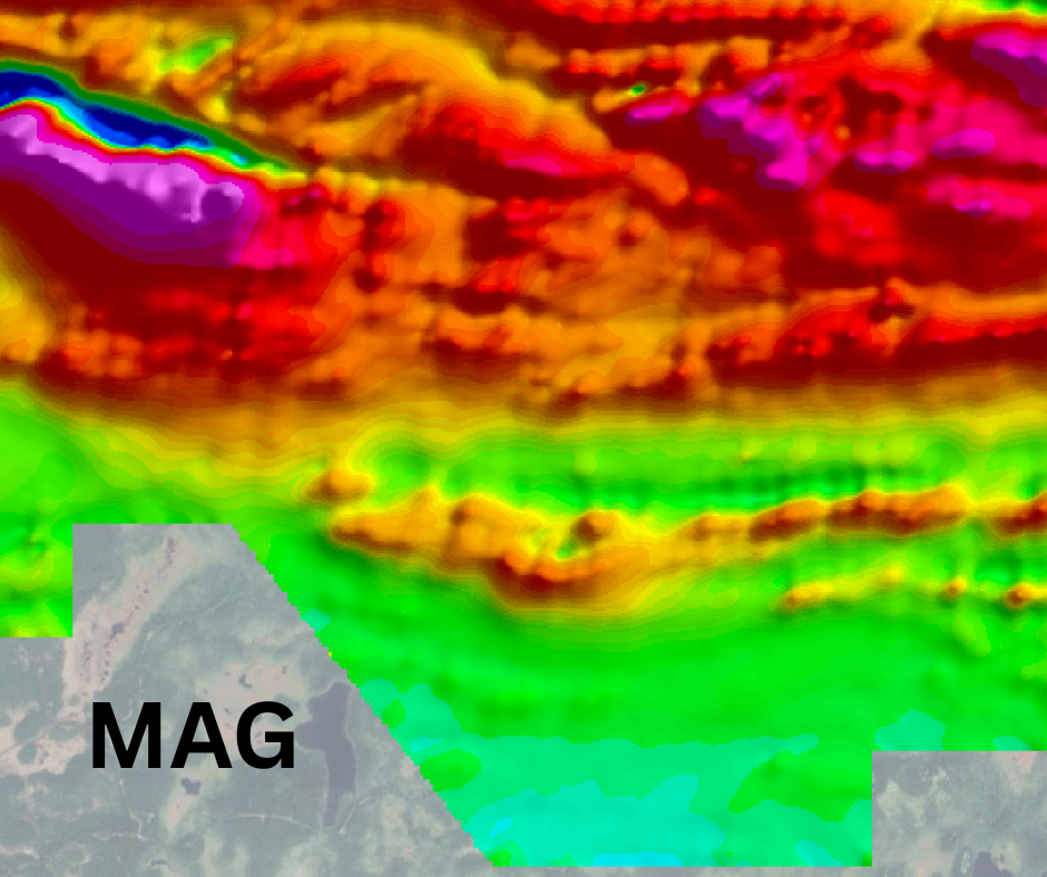
Airborne magnetic surveys are a core tool in mineral exploration, helping geologists understand the geological framework beneath the surface. Variations in the Earth’s magnetic field reveal differences in rock types, structures, and magnetic mineral content information that can highlight faults, dykes, intrusions, and other features that often control mineralization. By mapping these patterns across large areas, exploration teams can identify prospective trends and prioritize targets for follow-up work.
RPM supports this process with drone and helicopter magnetometer surveys designed around exploration objectives and site conditions. Drone systems provide efficient, high-resolution coverage for smaller properties or areas with straightforward access, while helicopter platforms enable consistent acquisition across large or remote terrain. Each survey is planned to meet the required line spacing and coverage needed for reliable geological interpretation.
The resulting datasets help geologists map lithology and structures, identify magnetic anomalies, and refine exploration targets. By delivering high-quality magnetic data tailored to the scale of the program, RPM helps exploration teams move from regional understanding to actionable targets for ground surveys, trenching, or drilling.
Magnetometer vs. VLF
Hover over the image to see
magnetometer and VLF comparison.
Looking to rent a magnetometer and have your collected data processed?
Give us a call at 1-888-776-8287 or contact us below!
")
Very Low Frequency (VLF) surveys are widely used in mineral exploration to identify conductive structures that may control mineralization. Faults, shear zones, graphitic horizons, and sulphide-bearing units can all produce conductive responses that appear as linear anomalies in VLF data. For early-stage programs, these surveys provide a fast and efficient way to screen ground and identify structural corridors worth investigating.
RPM conducts VLF surveys designed to produce clean, interpretation-ready datasets that integrate easily with existing exploration data, complimenting magnetometer deliverables. With extensive field experience across Newfoundland and Labrador, RPM plans surveys with a strong understanding of the region’s operating environment, enabling efficient field execution and delivering complete, dependable datasets for exploration teams.
The result is a clear view of conductive structures across the property, helping geologists identify prospective trends and focus follow-up exploration more effectively.

FAQs
Welcome to FAQs
Please select a frequently asked question from the menu below.
How do I choose between helicopter and drone (RPAS) magnetometer surveys?
The choice comes down to scale, terrain, accessibility, and the level of detail required. Helicopter surveys are typically more efficient for large or remote areas, allowing for consistent coverage over broad extents. RPAS (drone) surveys are better suited for smaller properties or priority zones where tighter and more accurate line spacing allows for closer terrain following, which is required for delivering higher-resolution data.
Many clients use both strategically. They start with helicopter coverage to identify targets, then deploy RPAS to refine specific areas of interest.
Why does RPM often recommend a LiDAR survey before an RPAS magnetometer survey?
For RPAS magnetometer surveys, maintaining a consistent sensor height above ground is critical, especially in areas with variable or complex terrain. RPM often recommends completing a LiDAR survey first to generate a high-resolution, accurate terrain model of the area.
This terrain data is then used to actively shape the RPAS flight plan, adjusting line elevations and profiles so the system can closely follow the ground surface throughout the survey. By planning flights around precise elevation data, RPM ensures more consistent clearance, cleaner data acquisition, and improved resolution, ultimately delivering magnetic datasets that are more reliable and easier to interpret.
How does RPM ensure consistency across large or multi-phase projects?
Consistency is built into both RPM’s equipment and methodology. By using the same potassium-based sensor across both RPAS and helicopter platforms, RPM ensures that data collected with different methodology (RPAS and Helicopter) remains fully compatible and directly comparable.
Combined with standardized acquisition and processing workflows, this allows datasets from different phases to integrate seamlessly, whether expanding regional coverage or infilling priority areas.
This is particularly valuable for programs that evolve over time. RPM’s experience working in Newfoundland and across Atlantic Canada further supports this consistency, with a strong understanding of local terrain, weather patterns, and logistics, enabling more effective planning and reliable execution from one phase to the next.
Can you match or tie into our existing magnetic datasets?
Yes. RPM can design surveys to align with legacy data in terms of line direction, spacing, and survey parameters where needed. This helps ensure continuity and allows new data to enhance or refine existing interpretations rather than complicate them.
What are the benefits of performing a VLF survey with RPM?
A VLF survey gives you a more actionable picture of the conductive features (non-magnetic material) that often coincide with mineralized systems or structures.
By highlighting conductive features like faults, shear zones, and sulphide-bearing units, VLF helps your team quickly identify the structural corridors most likely to host mineralization. This means less time guessing where to focus, and more confidence in where to invest follow-up work.
Just as importantly, VLF data enhances the value of your existing datasets. When integrated with magnetics, it helps key features “pop” more clearly. This brings subtle trends into focus and improves interpretation. The result is a more complete understanding of your property, allowing you to prioritize targets and move forward with greater certainty.
With RPM, VLF and Mag surveys are collected simultaneously, allowing our clients to gain these benefits for a minimal added cost to the overall project.