

Municipalities often struggle with asset management because infrastructure information is incomplete, outdated, or scattered across files, legacy drawings, and institutional memory. In some cases, municipalities have little or no centralized system for managing infrastructure data. In others, GIS systems already exist but staff capacity, competing priorities, or growing data backlogs make it difficult to maintain information or develop new tools. Without a reliable and well-maintained system, planning repairs, coordinating crews, and making capital decisions becomes slower, more uncertain, and costly.
RPM takes a solutions-based approach to helping municipalities improve how they manage and understand their infrastructure. For municipalities without an established GIS, this may begin with digitizing legacy maps, verifying existing records, and organizing infrastructure information into centralized GIS layers to create a reliable source of truth. Where legacy drawings or records are being updated, RPM validates information through available sources such as field checks and consultation with everyone who holds valuable institutional knowledge.
For municipalities that already have GIS systems in place, RPM can assist with improving data quality, addressing maintenance backlogs, and developing tools that support field data collection, infrastructure analysis, and day-to-day operational decision-making. By working with municipalities to identify their specific challenges, RPM uses GIS to build practical systems that improve infrastructure visibility, support maintenance and planning, and provide a foundation for more advanced capabilities as needs evolve.
Water systems are a common starting point. Many towns don’t fully know where underground assets are located or how much water is being lost. RPM’s water loss analysis tools, combined with GIS mapping of water infrastructure, help flag anomalies and narrow where losses are most likely occurring.
We Validate Our Info
We don’t just digitize your infrastructure, we do in-field validation to ensure that the information is accurate and your money is well spent.
How RPM Supports Municipal GIS:
- Digitizing legacy maps and records into structured GIS layers
- Verification of existing infrastructure records through field checks and consultation with everyone familiar with legacy systems
- Mapping municipal infrastructure such as water distribution networks, valves, hydrants, and related assets
- Development of centralized infrastructure inventories that act as a reliable source of truth for municipal assets
- Web mapping tools that support visualization, field data collection, system analysis, and operational dashboards
- Scalable GIS development, starting with priority systems and expanding as municipal needs evolve
A GIS That Grows With Your Municipality
RPM tailors each Municipal GIS to the municipality’s needs and budget. Systems are typically built in stages, beginning with priority infrastructure such as water distribution networks and expanding to include additional assets as priorities and funding allow.
Because the system is designed with a layered architecture, municipalities can start with core infrastructure mapping and gradually add capabilities such as field data collection, automated analysis, operational dashboards, and maintenance tracking as the system matures. This approach ensures the GIS remains practical to maintain while continuing to deliver increasing value over time. The result is a practical system that improves infrastructure visibility, supports better planning, and helps municipal teams work more efficiently.
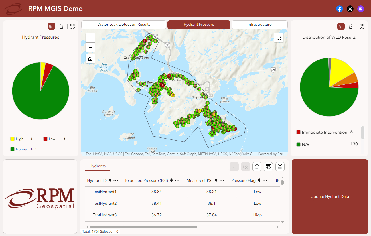
RPM MGIS Demo
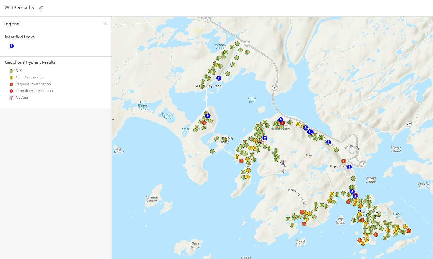
WLD Results
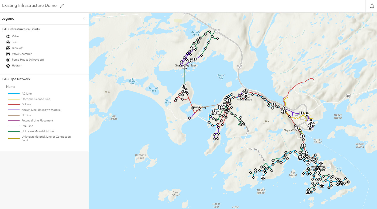
Existing Infrastructure
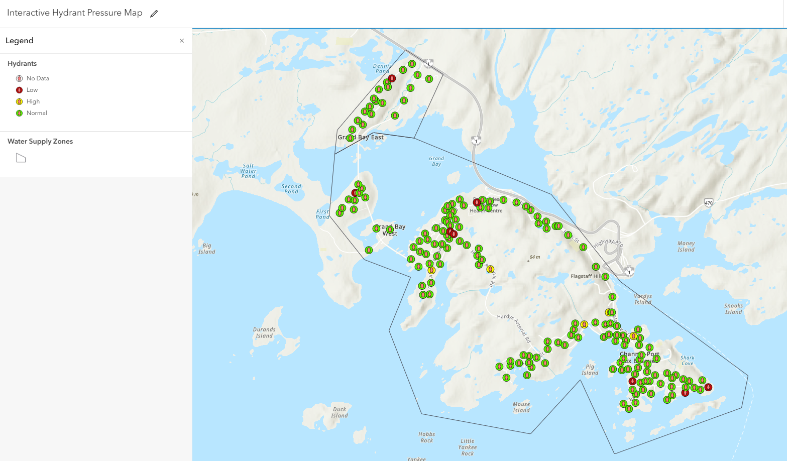
Interactive Hydrant Pressure Map
")
FAQ
Welcome to FAQs
Please select a frequently asked question from the menu below.
If we haven’t yet implemented a GIS program, how can RPM address our needs?
Many municipalities we work with are starting from paper maps, legacy drawings, or scattered records. We begin by digitizing and organizing your existing information into structured GIS features, creating a centralized and reliable source of truth for your infrastructure.
From there, we work with you to identify what matters most, whether that’s water systems, roads, or other priority assets, and build a practical GIS that supports your day-to-day operations. Our approach is phased and scalable, so you can start simple and expand over time as your needs and capacity grow.
What if we already have a GIS department or program, but the system is out of date or our internal capacity is overwhelmed?
We help municipalities regain control of their GIS by improving data quality, addressing backlogs, and putting structure around how data is maintained and utilized moving forward.
We start by reviewing your existing datasets to understand what’s there and where the issues are. From there, we clean and standardize the data, while identifying gaps, inconsistencies, or outdated information. We are also able to support data verification through field checks and consultation with staff and others with valuable institutional knowledge, ensuring the information reflects real-world conditions.
To further strengthen your system, RPM can incorporate new data collection through our own mapping and survey methods. This updates records and reduces long-standing backlogs. We then assist in establishing repeatable workflows so updates don’t continue to pile up, along with practical tools and processes that make your GIS usable in daily operations.
How can GIS help address water loss and assist in leak detection work?
A reliable and well-structured GIS is a key foundation for effective water loss analysis. When your water infrastructure is accurately mapped and organized, it becomes much easier to locate anomalies and narrow down where losses are occurring.
By building on a strong GIS foundation, municipalities can leverage a combination of mapping, RPM’s water loss and usage analysis tools, and custom applications to better understand and manage water systems. This can include tools that help visualize system performance, support field investigations, or track and validate findings over time. Together, these capabilities allow municipalities to move from broad assumptions to targeted investigation, helping crews focus their efforts, reduce unnecessary work, and make more informed repair decisions. Over time, this leads to better system understanding, a more targeted infrastructure replacement program, and reduced water loss.
How do you determine what GIS tools or capabilities our municipality actually needs?
We take a solutions-based approach, starting with an understanding of your current workflows, challenges, and priorities. Every municipality is different, so rather than applying a one-size-fits-all solution, we work with you to identify where GIS can provide the most immediate and practical value.
This may involve improving how infrastructure is tracked, enabling better field data collection, supporting planning decisions, or creating tools that help staff quickly access and update information. From there, we develop and integrate the right combination of data structures, workflows, and tools to support those needs.
Our goal is to build a system that fits your team, not one that adds unnecessary complexity. We develop solutions that can expand as your municipality’s needs and capabilities grow.
Will this actually be something our staff can use day-to-day?
Absolutely. Our focus is on building GIS that is practical and aligned with your municipality’s capacity and how your team already works. That means creating tools, supporting workflows, and providing data for real tasks, whether that is understanding water usage, identifying potential leaks, tracking infrastructure performance, or supporting planning and operational decisions.
We recognize that not every municipality has a dedicated GIS team, or even a single person responsible for it. That is why we tailor our approach to match your internal capabilities. For some clients, that means delivering simple, easy to use tools that require minimal upkeep. For others, it may involve RPM taking on a more active role in managing, updating, or supporting the system over time.
Our goal is to provide solutions that are accessible, sustainable, and applicable, not systems that add complexity or sit unused. As your needs and capacity grow, the GIS can evolve with you by adding new tools and capabilities at a pace that makes sense for your municipality.